
The previous two 'shared coordinates' posts have been pretty popular and a few people have asked about vertically positioning the building. That question is answered in today's post!
Using this workflow, the Revit topo contours will match civil and can even be labeled. All of this is covered in a YouTube video I created, which is linked below!

Since the full workflow is covered in the video, I will give a brief overview here of the process of setting up shared coordinates with the vertical position in mind.
Site Model Set Up
Start here, doing the following in the Revit site model:
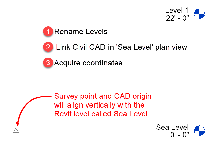
- Rename the levels
- 0'-0" should be named Sea Level
- Additional levels are optional, but one per building can be helpful
- Open Seal Level plan view
- Link in Civil CAD file
- In plan, move link near Revit's internal origin
- In elevation/section, ensure the CAD origin aligns with Sea Level (it should already be in the correct vertical position)
- Acquire coordinates
Building Model Set Up
In the building model:
- Link and position the site model per the previous post
- In section/elevation, move the site link so both Level 1s align
- Acquire coordinates

Results
Once the building model is linked into the site model, using shared coordinates, it will drop into the correct place, including vertically as shown here.

Moving the Building Vertically, Later On
If, or when, the building needs to move vertically later on in the project do the following:
- Open the building model
- In a selection/elevation, move the Survey Point vertically in the opposite direction you want the building to move on the site.
- Save and close
Next time you open the site model, the building will be in the correct location as shown below (click to enlarge image).

Tips
Here are a few tips to keep in mind:
- Never move anything in the site model once shared coordinates are set up
- Never unclip the survey point
- This only complicates things
- If you want a N/E reference at a local benchmark or grid intersection, just add a Spot Coordinate
- The SP can/should just live aligned with the Civil CAD origin
- Remember, sometimes the SP might be behind you if not visible in elev/sect
- Revit 2021 has a command to Reset Shared Coordinates if things get messed up
YouTube Video
I recorded the the workflow in a video...
For BIM Chapters updates, follow @DanStine_MN on Twitter or connect on LinkedIn
Check out my video-based courses on ArchSmarter.
I also write blog posts for Enscape - a new paradigm in rendering, animation and VR for AEC.
Additional Posts
Here are a few addition posts on this topic:
For BIM Chapters updates, follow @DanStine_MN on Twitter or connect on LinkedIn
Check out my video-based courses on ArchSmarter.
I also write blog posts for Enscape - a new paradigm in rendering, animation and VR for AEC.